ARTICLE AD BOX

 Laxman Adhikari
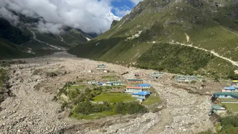
Thame village was devastated in recent floods
Sitting at an altitude of around 3,800m (12,467ft) is Thame, a small Sherpa village in Nepal's Everest region.
It is home to many record-holding Sherpa mountaineers, including Sherpa Tenzing Norgay, the first person to climb Mount Everest along with explorer Edmund Hillary.
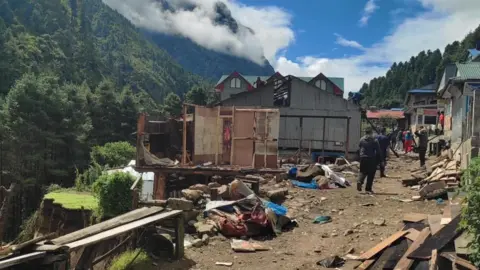
But on 16 August, the village was engulfed by icy flood waters after a glacial lake burst its banks, displacing some 60 people and destroying more than a dozen houses and hotels along with a school and health clinic.
The incident has left many of the village's residents - around 300 people - wondering whether it is even safe to live there any longer.
'We are still in shock'
No deaths or injuries were reported, but members of the Sherpa community said they were lucky that the flood hit during daytime, when everyone was awake and the alerts arrived quickly.
“If this had happened at night time, between 200 to 300 people would have lost their lives,” Ang Tshering Sherpa, former president of Nepal Mountaineering Association said.
“We are still in shock, and we are still crying when we (villagers) talk to each other,” said Yangji Doma Sherpa, a native of Thame who was born in the village.
“The bigger question is if this place is safe enough to live in now. This flood has shown that we face an even more dangerous situation now, and therefore people don’t feel safe.”
Other villagers downhill have similarly been affected.
“Because of the flood some parts of our village was swept away... luckily we managed to run up the hill,” said Pasang Sherpa at Tok Tok village which is almost two days’ trek downhill from Thame.
“The otherwise milky and frothy river turned so dark brown, with boulders and debris being swept down.
The sound and the sight was so scary that I am still shaken. I have taken refuge in a nearby village and am thinking if I should ever go back to Tok Tok.”
Locals say much of the risk could be reduced if there were proper monitoring mechanisms for glacial lakes located upstream from human settlements.
While a few lakes have drawn the attention of scientists and authorities, they added, the rest are simply ignored.
Meanwhile, disaster preparedness is non-existent in many villages.
"A few villages downstream of the Imja glacial lake have been trained on how to run in case of a flood,” Ms Doma Sherpa said.
“But there has been no training in our village whatsoever.”
Of the more than one dozen glacial lake outburst incidents recorded in Nepal in the past 50 years, four have been in the Everest’s Dudhkosi river basin.
One occurred upstream of Thame in 1985, when a large avalanche cascaded into the Dig Tsho glacial lake and created a wave that overtopped the dam. The ensuing flood destroyed a hydroelectricity plant downstream and caused more than three million dollars worth of damage.

 Khumbu Pashanlhamu Rural Municipality
Many people in the disaster-prone Everest region are wondering whether it's safe to remain
Small lakes, big risks
The lack of monitoring is not a problem that is unique to just Thame.
There are thousands of glaciers and glacial lakes in the Himalayas – but very few in the Everest region are monitored and have early flood warning systems installed.
Meanwhile, global warming is accelerating the melting of glaciers which can fill up the lakes to bursting point.
A 2021 study led by the University of Leeds found that Himalayan glaciers have lost ice ten times more quickly over the last few decades than the average rate measured since their expansion 400 to 700 years ago.
Another study published in the Nature journal in 2022 found that Mount Everest’s South Col Glacier may have lost half its mass since the 1990s as a result of warming.
Imja Lake below Mount Everest was drained in 2016 after officials found it was in danger of overflowing and flooding downstream settlements, trekking trails and bridges.
But scientists have found that many new lakes have formed in recent years, while others have expanded and joined up to become larger ones.
Further inflaming the risk is the destabilisation of the local landscape caused by fast-retreating glaciers, leading to more landslides and avalanches that can pour into the lakes and cause them to rupture.
Authorities say they have listed around two dozen glacial lakes across the Nepali Himalayas as risky - but the two that burst on 16 August were neither mentioned in that list nor monitored by officials.
“They were the smallest ones and no one cared about them, and yet the damages have been so huge,” said Mr Tshering Sherpa.
“Imagine what could happen if the big ones burst out. There are many of them in the Everest region.”
Officials from Nepal’s Disaster Risk Reduction and Management Authority (NDRRMA) conducted a helicopter inspection and found there were a total of five small glacial lakes located near the source of the flooding. One of them had partially burst; another had burst completely.
“Which means the three other lakes at the same location could burst out anytime in the same way,” said Ms Doma Sherpa.
“Now that people know that, they don’t feel safe anymore. We are worried particularly about elderly people because of their mobility issues.”

 Khumbu Pashanlhamu Rural Municipality
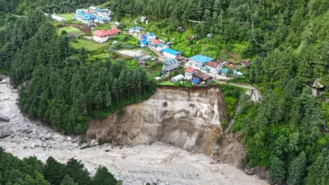
Erosion from flooding is placing more settlements at risk of collapse
'Cut off from the outside world'
Since then, the impacts of global warming on Himalayan glaciers and lakes has only become more striking – and locals say some damages from floods are now irreparable.
While the Thame river used to flow through the left part of the Khumbu valley, Friday’s flood has made it change course. Now it flows right through the village, claiming almost half of the land.
“Much of the remaining land now is full of debris and boulders,” Ms Doma Sherpa said.
“This is not like rebuilding the houses destroyed by the quake. When you have no land left, what can you build on?”
The flood has also damaged the reservoir of the only hydropower station that provides electricity to the region.
The station stopped functioning after the disaster led to deposition of mud and debris in the reservoir.
“As a result, power supply has been cut off, and because of that telecommunication systems were also not functioning,” Mingma Sherpa, chair of a youth club at Namche, a major tourist spot near Thame, said.
“The area has remained cut off from the outside world since the disaster struck. This is quite scary.”
“We had been worrying about slow onset impacts of climate change, like dwindling water resources, but this disaster has shown how unsafe and vulnerable we are.”
Government officials are aware of locals’ fears.
Anil Pokhrel, head of NDRRMA, said the authority is now forming a team of experts that will “study the risks posed by the three remaining lakes upstream of Thame village and find out if the downstream settlement areas are safe for people to live in or not".
“We are also working on disaster risk reduction in the region,” she added.
Members of local Sherpa communities, however, say they’ve seen more talk and less action over the years when it comes to dealing with risks from glacial lake outbursts.
“We hear all big plans, especially during conferences, and soon the plans are forgotten,” Ms Doma Sherpa said.
“But we can’t forget about what this flood has done - and that there are other lakes lurking up there that can unleash disasters on us anytime.”

 3 months ago
14


 English (US)