ARTICLE AD BOX
 Image source, NOAA via Reuters
By Brandon Drenon
BBC News, Washington
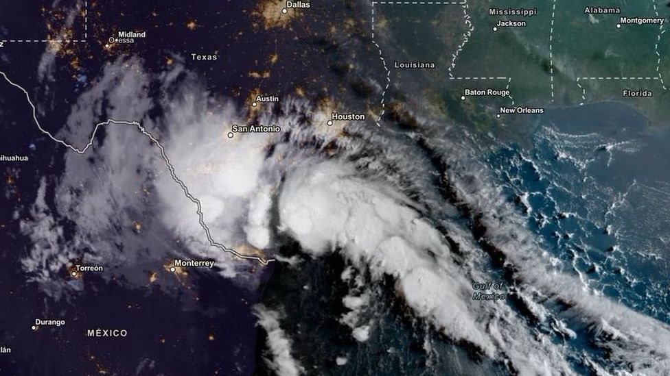
Tropical Storm Harold has made landfall on the south-east coast of Texas, bringing more heavy rain and high winds to the southern US.
Multiple flash flood and tornado warnings are in place on Tuesday and expected to last into the afternoon.
National Weather Service officials predict 1-3in (2.5-7.6cm) of rainfall in under an hour in some regions.
The Texas deluge arrives a day after historic amounts of rain flooded parts of the US southwest.
California and Nevada are cleaning up on Tuesday after parts of each states saw historic amounts of rain from Storm Hilary, which caused widespread flooding along with mudflows, downed powerlines and trapped cars.
The National Weather Service (NWS) is also tracking two additional tropical storms moving west towards the US.
On Tuesday, around 10:00 local time (16:00 BST), Tropical Storm Harold made landfall on Texas' Padre Island in the Gulf of Mexico.
Tropical storm warnings have been issued from the Rio Grande river - along the state's southern boundary - to roughly 250 miles (400km) north, to the community of Port O' Connor.
More than one million people are under tropical storm warnings in the Lone Star state. Scattered instances of flash flooding will be possible, the NWS warned.
Wind speeds reached up to 50mph (80km/h), prompting the NWS to issue a tornado warning for counties in south-central Texas. Residents there have been cautioned by officials to stay indoors as "flying debris will be dangerous".
By Tuesday afternoon, 2-4in of rain had fallen in some south-eastern Texas counties, with up to 6in forecast to fall in some isolated areas.
A couple of tornadoes are possible across south Texas through Tuesday afternoon.
The storm is expected to continue to carry rain, wind and hail further inland as it tracks westward across the hot and dry Texas landscape.
As Texans endure the deluge, weather officials have warned of yet another tropical storm - Tropical Storm Franklin - currently some 230 miles east off the coast of the Dominican Republican.
Up to 6in of rain from Franklin is predicted to fall in Puerto Rico beginning on Wednesday.
The impact of climate change on the frequency of storms is still unclear, but we know that increased sea surface temperatures warm the air above and make more energy available to drive hurricanes, cyclones and typhoons. As a result, they are likely to be more intense with more extreme rainfall.
The world has already warmed by about 1.1C since the industrial era began and temperatures will keep rising unless governments around the world make steep cuts to emissions.

 1 year ago
19


 English (US)