
 1 year ago
52
1 year ago
52
ARTICLE AD BOX
Satellite images analysed by BBC Verify show damage to a number of military sites in Iran from Israeli air strikes on Saturday.
They include sites experts say were used for missile production and air defence, including one previously linked to Iran’s nuclear programme.

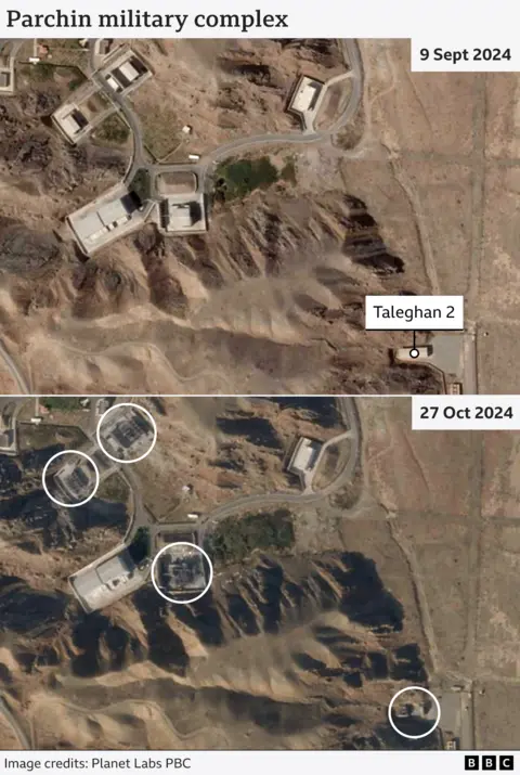
Satellite imagery following the Israeli strikes shows damage to buildings at what experts say is a major weapons development and production facility at Parchin, about 30km (18.5 miles) east of Tehran.
The site has been linked to rocket production according to experts from the International Institute for Strategic Studies (IISS).
Comparing high-resolution satellite imagery taken on 9 September with an image captured on 27 October, it appears that at least four structures have been significantly damaged.
One of these structures, known as Taleghan 2, has been previously linked to Iran’s nuclear programme by the International Atomic Energy Agency (IAEA)
In 2016 the IAEA found evidence of uranium particles at the site, raising questions about banned nuclear activity there.
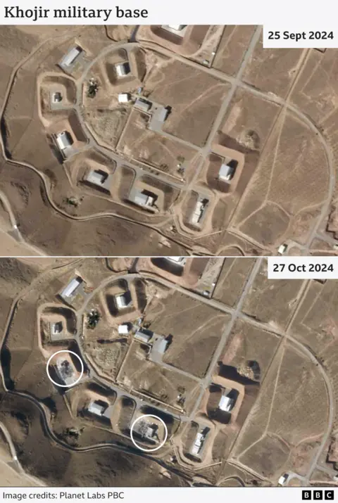
Another site apparently targeted in the Israeli air strikes is at Khojir, about 20km north-west of Parchin.
Fabian Hinz of the ISS says “Khojir is known as the area with the highest concentration of ballistic missile-related infrastructure within Iran.”
It was the site of a mysterious large explosion in 2020.
Satellite photos show at least two buildings in the complex appear to have been severely damaged.
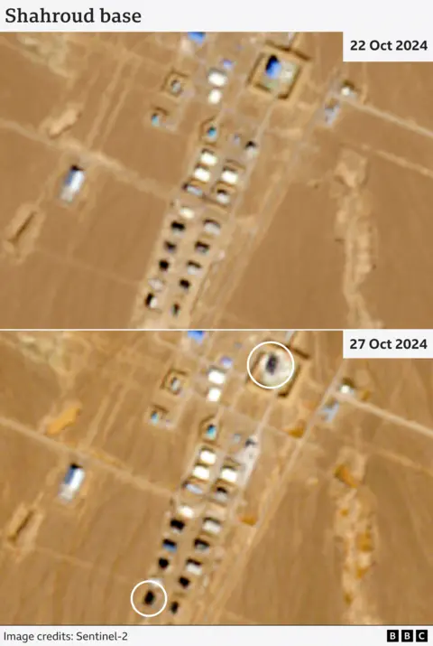
A military site at Shahroud, about 350km to the east of Tehran, has also sustained damage, according to satellite imagery taken after the Israeli strikes.
Located in the northern porvince of Semnan, this area is significant because it’s been involved in the production of long-range missile components, according to Fabian Hinz of the IISS.
Nearby is the Shahroud Space Centre, controlled by the Revolutionary Guards Corps, from which Iran launched a military satellite into space in 2020.
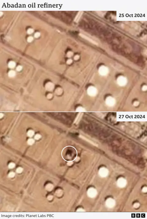
BBC Verify has identified what appears to be damage to a storage unit at the Abadan Oil Refinery based in the south-western province of Khuzestan.
However, we don’t know what caused it and there is likely to be damage in some areas across Iran caused by debris or misfiring defence systems.
The New York Times cited Israeli officials as saying that the Abadan oil refinery was one of the sites targeted in its air strikes on Saturday morning.
Iranian authorities confirmed on Saturday that Khuzestan province had been targeted by Israel.
Abadan oil refinery is the country’s largest, capable of producing 500,000 barrels a day, according to its chief executive.
Satellite imagery isn't always conclusive in identifying damaged structures.
For example, a photograph we have verified showing smoke rising near Hazrat Amir Brigade Air Defence base suggested it had been successfully targeted. But satellite imagery of the area captured on Sunday has too many shadows to confirm any damage to the site.
Iran launched a missile attack on Israel at the start of October for the second time this year, after firing 300 missiles and drones in April.
Additional reporting by Tom Spencer and Daniele Palumbo


 English (US) ·